

A catastrophic flash flood tore through the Nepal-Tibet border region on August 26, 2026, after a glacial collapse sent a wall of ice, rock, and water crashing down the Lhende Khola into the Bhotekoshi and Trishuli river systems. Within hours, the disaster had swept away homes, bridges, and hydropower infrastructure in Nepal's Rasuwa and Nuwakot districts, while also destroying the Gyirong border crossing on the Chinese side. If you're trying to cut through the scattered live-blog updates and understand what actually happened, here's the full picture.
 Nepal Flash Flood 2026: What Happened, Who's Affected, and What We Know So Far
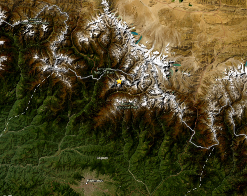
The yellow star indicates the location of the landslide and glacier collapse identified by the USGS. The resulting Nepal flash flood devastated villages, while the exact death toll remains unknown as rescue efforts continue.
What Happened in the Nepal Flash Flood 2026
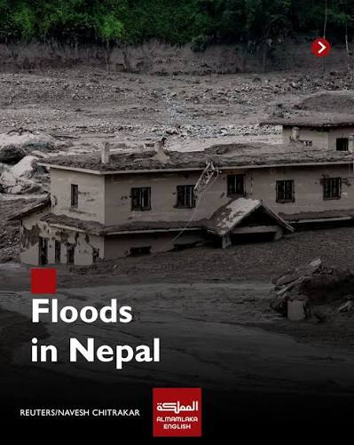
It started high in the mountains, not in a village. On the morning of August 26, a mass of glacial ice and rock broke loose at extreme altitude near the Nepal-Tibet border and began racing downhill, picking up debris as it went. By the time it reached the Lhende Khola a tributary that feeds into the Bhotekoshi river it had become a fast-moving slurry of mud, boulders, and meltwater powerful enough to flatten buildings in its path.
The surge continued downstream into the Trishuli river system, affecting communities well beyond the initial impact zone. Locals in the Nuwakot district described the water rising with almost no warning, giving residents only minutes to evacuate before it hit.
This wasn't an isolated freak event, either. A similar though smaller glacial lake overflow hit the same general area in August 2025, killing nine people and damaging a bridge connecting Nepal and China. That earlier flood should have been a warning sign for how exposed this river corridor really is.
What Caused the Flood
Glacial Collapse, Not a Landslide From Nowhere
Satellite imagery reviewed by researchers, including geoscientist Dan Shugar, shows the flood's origin point clearly: a chunk of glacier collapsed and dropped a significant distance before slamming into the valley below, dragging rock and sediment into the river system with it. This is functionally a glacial lake outburst flood (GLOF) a hazard that's become more common across the Himalayas as glaciers retreat and destabilize.
Was It an Earthquake?
This is one of the most-searched questions about the disaster, and the honest answer is: not really, though it's easy to see why people assumed so. Seismic monitors picked up a signal that early reports interpreted as a small earthquake. But that signal was consistent with the mass and force of the landslide itself hitting the ground not a tectonic event that triggered it. In other words, the "quake" was a symptom of the collapse, not its cause.
Did Climate Change Play a Role?
It's tempting to draw a straight line from climate change to this specific event, but that's not how glacial hazards work no single disaster can be attributed to warming with certainty. What's fair to say is that rising temperatures are destabilizing high-altitude ice and expanding glacial lakes across the region, and scientists broadly agree this raises the baseline risk of exactly this kind of collapse. Think of it less as "climate change caused this flood" and more as "climate change is loading the dice."
Where the Flood Hit Hardest
Rasuwa district bore the brunt of the initial impact its proximity to the Tibet border and the Lhende Khola put it directly in the flood's path. The border town of Timure was largely destroyed; before-and-after satellite images show a river corridor that used to hold a functioning town now scoured down to bare ground and rubble.
Syabrubesi, a key gateway town for the Langtang trekking region, was also affected, raising immediate questions for anyone with a Langtang trip booked.
Downstream, Nuwakot absorbed the worst of the secondary flooding as the surge moved into the Trishuli river, with reports of damage extending further into Dhading, Gorkha, and Chitwan as authorities kept monitoring river levels.
Who's Been Affected
The flood hit an unusually mixed population. Rasuwa isn't just a residential district it's also home to hydropower construction crews, security personnel stationed near the border, and a steady flow of trekkers and pilgrims. That combination is part of why the missing-persons list is so broad.
 Nepal Flash Flood 2026: What Happened, Who's Affected, and What We Know So Far
Local Residents and Workers
Villagers, hydropower employees, and Nepali security forces near the border were among those caught in the flood zone, along with damage to at least two hydropower schemes along the Bhotekoshi corridor.
Foreign Tourists and Kailash Pilgrims
A significant number of those unaccounted for were foreign nationals many traveling toward Mount Kailash in Tibet, a major Hindu pilgrimage site reached via this exact border crossing. Reports also point to trekkers who were in the Gosaikunda lake area, a popular route that happened to coincide with a Nepali festival period.
We're deliberately not repeating nationality-by-nationality missing-person counts here, since those figures have shifted daily check official embassy channels for country-specific updates rather than relying on any single article's snapshot.
Death Toll and Missing Persons — Latest Figures
Category | Latest Reported Information (as of Aug 27, 2026) |
|---|---|
Confirmed deaths | Ranges reported from ~150–180+ across Nepal and Tibet combined; expected to rise |
Missing | Several hundred, including foreign nationals |
Main affected district | Rasuwa, with downstream impact in Nuwakot |
Rescue status | Ongoing |
Note: These figures are moving targets. Rely on Nepal's Ministry of Home Affairs, the Nepal Tourism Board, and your country's embassy in Kathmandu for the most current numbers rather than any single news snapshot including this one.
Infrastructure and Economic Damage
Beyond the human toll, the flood tore through the physical backbone connecting Nepal and Tibet. The Gyirong border crossing a genuinely important trade and pilgrimage route between the two countries was badly damaged, along with roads and bridges on both sides. Multiple hydropower facilities along the Bhotekoshi were also hit, which matters well beyond the immediate area: this river corridor has historically supplied a meaningful share of Nepal's electricity, so repeated damage to hydropower assets here has ripple effects on the national grid.
Communication networks in the hardest-hit areas were also disrupted, which has slowed both rescue coordination and the flow of reliable information part of why figures on this disaster have varied so much between sources.
 Last updated: August 27, 2026. Casualty and missing-person figures are changing quickly as search and rescue operations continue treat any specific number below as a snapshot, not a final count.
Rescue and Relief Operations
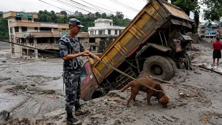
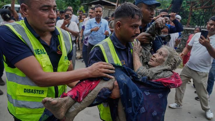
Nepal's army, police, and helicopter units have been running search-and-rescue missions since the first hours of the flood, though damaged roads, high water, and unstable terrain have made access to some areas genuinely difficult not just logistically inconvenient. On the Chinese side, authorities in Gyirong county have been conducting parallel search operations, reportedly ordered to intensify efforts at the highest level.
International support has followed quickly: the International Federation of Red Cross and Red Crescent Societies (IFRC) has released emergency funding to support the Nepal Red Cross response, and several governments with missing citizens have offered consular and logistical assistance.
 Nepal Flash Flood 2026: What Happened, Who's Affected, and What We Know So Far
Is It Safe to Travel to Nepal Right Now?
This deserves a real answer, not a blanket yes or no because it depends entirely on where you're going.
Kathmandu itself has not been directly hit by the flood. The disaster zone is roughly 100+ km north, along the Tibet border. That said, transportation disruptions and downstream river monitoring can still create indirect delays even for travelers based in the capital.
Everest region routes are not in the affected corridor and, based on current information, are operating normally but always confirm with your trekking agency before departure, since conditions can change with continued monsoon activity.
Langtang region and Rasuwa-area routes, including access via Syabrubesi, are directly affected and should be avoided until local authorities confirm the roads and trails are safe again.
Annapurna region and Manaslu routes are in a different part of the country and unaffected by this specific event, though it's worth checking your operator's latest advisory regardless Himalayan trekking conditions can shift fast for reasons unrelated to this flood.
Why Flash Floods Keep Happening in the Himalayas
This disaster isn't a one-off. The Himalayas combine steep terrain, rapidly flowing glacial rivers, unstable moraine-dammed lakes, and increasingly erratic monsoon rainfall— a mix that makes sudden, high-force flooding a recurring risk rather than a rare exception. Add in glaciers that are visibly retreating and destabilizing under warming conditions, and you get a landscape where a single high-altitude collapse can turn into a disaster hundreds of kilometers downstream within hours. Nepal has seen variations of this same story in 2025, and in multiple years before that.
Frequently Asked Questions
What happened in Nepal on August 26, 2026?
A glacial collapse near the Nepal-Tibet border triggered a flash flood that swept down the Lhende Khola into the Bhotekoshi and Trishuli river systems, destroying communities in Rasuwa and Nuwakot districts.
Where did the Nepal flash flood occur?
Primarily in Rasuwa district near the Tibet border, with downstream impact reaching Nuwakot, Dhading, Gorkha, and Chitwan.
What caused the Nepal flash flood?
A glacial ice and rock collapse at high altitude, not an earthquake though a seismic signal from the impact was initially mistaken for one.
How many people died in the Nepal flash flood?
Confirmed deaths are in the range of 150–180+ as of this writing, across Nepal and Tibet combined, and expected to rise. Check official sources for the current count.
How many people are missing?
Several hundred, including a significant number of foreign nationals and pilgrims traveling toward Mount Kailash.
Were tourists affected?
Yes,many of those missing were foreign trekkers and pilgrims traveling through the Rasuwa-Gyirong corridor.
Was the flood caused by an earthquake?
No. The seismic reading came from the force of the landslide itself hitting the valley floor.
Is it safe to travel to Nepal after the flood?
Kathmandu and most major trekking regions (Everest, Annapurna, Manaslu) are unaffected. Langtang and Rasuwa-area routes should be avoided until officials confirm it's safe.
Are Nepal's trekking routes open?
Most are, outside the direct disaster zone but confirm current status with your trekking operator before you travel.
Plan your trek
Want to Plan Your Holiday in Nepal?
Tell us your dates and fitness level. A local expert replies within a day with a private itinerary and price.
Conclusion
The Nepal flash flood of August 26, 2026, started with a glacial collapse high in the mountains and ended up affecting communities, infrastructure, and travelers across an entire river corridor within hours. Rasuwa and the Gyirong border crossing took the hardest hit, while downstream areas in Nuwakot and beyond dealt with the secondary surge. Rescue operations are ongoing on both sides of the border, and casualty figures are still being updated daily. If you're following this story or planning travel in the region lean on official sources for the latest numbers and route conditions, since the situation is still developing.